Devastating European wildfires in maps – and how they’re being tackled
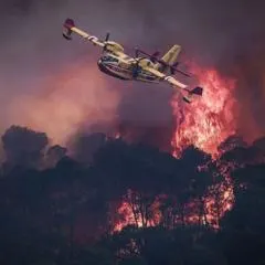
Wildfires raging across France and Spain have forced more than 300,000 people to evacuate their homes, with France recording more land burnt than in any year this century and Madrid officials calling the blazes the worst the region has ever seen. The fires follow a summer of intense heatwaves across Europe, with temperatures exceeding 40C in many places, and climate change is understood to be intensifying their spread by creating hotter, drier conditions.
The worst-hit area is Gironde near Bordeaux, where over 200,000 people have fled and the fire has burnt more than 162 square miles in under four days, now just nine miles from southern Bordeaux, threatening sensitive military and industrial sites. The blaze has grown so intense it has generated its own fire thunderstorm capable of producing lightning that sparks new fires. Around 2,500 firefighters, 1,500 military personnel and 1,200 police are tackling the Gironde fire using water-scooping planes, fire retardant and bulldozed firebreaks up to 100m wide, with Spanish teams employing similar tactics amid what officials describe as Madrid's largest fire on record.
- Wildfires force 300,000+ evacuations across France and Spain
- Gironde fire near Bordeaux burns 162 sq miles in four days
- Fires created a rare fire-generated thunderstorm with lightning