Technology news and discussion on TalkFuse.
Google pulls new Earth AI tool after people use it to put fake nuclear power plants in Iran and refugees near the Mexican border
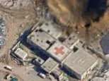
Google withdrew a new AI editing feature in Google Earth within 24 hours of launch after users showed it could generate convincing fake satellite imagery of sensitive real-world scenarios. The tool, powered by Google's Nano Banana 2 image-generation model, let people type prompts to alter satellite, aerial or 3D imagery, but it was quickly exploited to produce fabricated scenes including a nuclear plant in Iran, refugees near the US-Mexico border, a bomb crater in Gaza and a car crash in Amsterdam, prompting the company to pull the feature while it builds stronger safeguards.
The feature was announced on Thursday and taken down on Friday after OSINT researcher Hank van Ess and others demonstrated that the tool refused none of their harmful prompts, generating imagery without warnings. Google said generated images did not appear in the main Google Earth experience for other users and that every image carried a traceable watermark linked to its Gemini AI model. The episode adds to wider concerns about AI-generated disinformation, following earlier incidents such as fake satellite images of an Iranian strike on Qatar and a viral fake video of Dubai's Burj Khalifa on fire, and comes as platforms like X tighten rules on unlabelled AI content depicting conflict.
In short
- Google pulled its new Earth AI image tool a day after launch
- Users made fake nuclear plants, refugees and bomb craters
- Google cited policy violations, promised stronger safeguards before relaunch
Steelman: both sides, in good faith
The strongest fair case each way — we don't pick a winner.
The case for
Google's immediate withdrawal may have been unnecessarily cautious and counterproductive to responsible AI development. The feature included safeguards such as watermarks linking generated images to Gemini, remained inaccessible to mainstream users, and offered potential for legitimate applications. Testing by security researchers demonstrates proof-of-concept vulnerabilities rather than evidence of real-world harm; allowing iterative improvement with proper safeguards produces more robust systems than preemptively withdrawing features, which may discourage responsible innovation in AI.
The case against
Satellite imagery possesses particular power to fuel geopolitical disinformation, as demonstrated by recent fabricated images of Iranian strikes. The tool's complete failure—refusing no harmful prompts and generating no warnings—revealed fundamental safeguard weaknesses beyond watermarking. Once such capability exists, even confidentially, proliferation and misuse become difficult to prevent. Google's swift removal appropriately prioritised preventing potential disinformation that could shape policy and public perception over the convenience of an editing feature.
Explained simply
Google Earth uses satellite, aerial and 3D images to show places around the world. Generative AI can create or change images from written instructions, so an editing tool can make a real location appear to show something that never happened.
Google is a technology company that runs Google Earth and makes the Gemini family of AI models. Open-source intelligence researchers, including Hank van Ess, examine publicly available material such as maps and images; their demonstrations showed how altered imagery could depict events involving Iran, Gaza or the US-Mexico border.
Fake images can be mistaken for evidence, particularly during conflicts or other fast-moving events. Watermarks and limits on where images appear may help identify them, but the episode raises questions about how AI tools should prevent misleading edits and how viewers can assess images they encounter.
AI Art Culture Middle East Technology World