How beachgoers are turning snaps into science
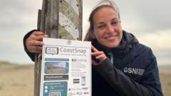
Beachgoers at Tyrella Beach in County Down are being invited to become citizen scientists, using their smartphones to help researchers track how the Northern Irish coastline is changing. Visitors take a photo through a fixed steel cradle and upload it via a QR code to the CoastSnap website, building a growing photographic record that scientists will use to monitor coastal erosion, rising sea levels and the effects of climate change. It is the first CoastSnap photo spot in Northern Ireland.
The project is led by geomorphologist Melanie Biausque of Geological Survey Northern Ireland and forms part of a wider scheme called Co-creating Coastal Resilience (CoCor); CoastSnap itself began in Australia. Tyrella was chosen because local volunteers have already worked to restore its sand dunes by planting marram grass and installing protective fencing. By comparing many photos taken from exactly the same position over months and years, researchers can see how the beach responds to different seasons and weather. Participation is anonymous and free, the Northern Ireland branch is funded by the Department for the Economy, and more sites are due to be equipped, with open days planned to show people how to take part.
- Beachgoers can photograph Tyrella Beach to help scientists track coastal change.
- CoastSnap uses a fixed phone cradle for consistent, comparable images.
- Participation is free, anonymous, and funded by the Department for the Economy.