How ‘fire-generated thunderstorms’ make wildfires more deadly
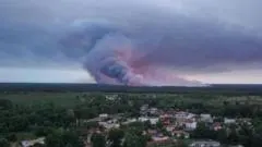
Tens of thousands of people have been evacuated from the Gironde region around Bordeaux as firefighters battle wildfires that have generated an unprecedented "pyrocumulonimbus" cloud in France. These "fire-generated thunderstorms" form when intense heat from a blaze forces air to rise rapidly, carrying smoke, ash and water vapour high into the atmosphere, where it cools and condenses into a towering thundercloud; this creates turbulent winds that scatter embers unpredictably and can trigger lightning strikes that spark new fires, making the blazes far harder to control.
French authorities say the phenomenon has never previously been recorded in the country, and warn the Gironde fire could burn for weeks and take months to fully extinguish, with another heatwave of up to 40C forecast this week. Scientists note such clouds are more likely amid high temperatures, strong winds and low moisture, and expect climate change to make them more frequent, pointing to precedents including Australia's 2019-2020 Black Summer bushfires, which killed at least 33 people and burnt over 11 million hectares, and major fires in California in 2021.
- French wildfires near Bordeaux create rare, unprecedented "fire-generated thunderstorm" clouds
- Pyrocumulonimbus clouds spread embers and lightning, worsening wildfire spread
- Scientists warn climate change will make such extreme fire events more common