Orbify.eu pitches warped Inception-style 3D maps for navigation
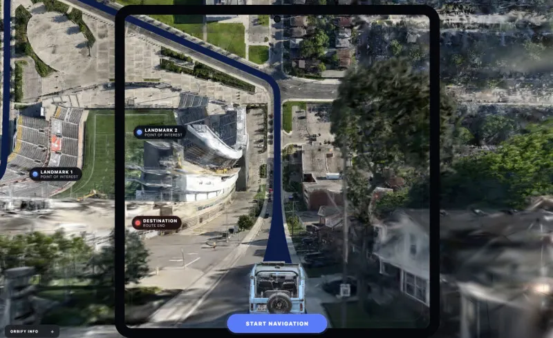
Orbify.eu, a two-year-old Norwegian startup, is developing navigation software that renders 3D maps in a warped, Inception-style perspective, blending a street-level view close to the user with an overhead view further away. Co-founded by former Snøhetta architect Karsten Huitfeldt, the company hopes the design will let drivers and pedestrians understand their surroundings without switching between separate map views, addressing what it sees as stagnation in navigation interface design despite advances elsewhere in automotive tech.
The firm, backed by initial funding from Innovation Norway and Norges forskningsråd, has filed an unpublished EU patent (PCT/EP2026/058725) covering its bending algorithm, shader and camera setup, and last week released a browser-based demo built on the PlayCanvas engine using Gaussian splatting. Huitfeldt says the core technology works and is publicly demonstrable, but no formal study has yet tested whether it actually improves navigation compared with conventional map views, and the company is not claiming superiority ahead of such evidence. Orbify intends to offer the technology as a software/SDK layer compatible with existing 3D mapping and navigation systems rather than building its own mapping platform.
In short
- Norwegian startup Orbify.eu built Inception-style warped 3D navigation maps
- Combines street-level and aerial views into one continuous perspective
- Patent pending; no user study yet proves navigation benefits
Explained simply
Digital maps generally show nearby streets and the wider area in separate views or at different scales. Orbify.eu is a Norwegian start-up developing a 3D display that combines a close street-level view with an overhead view further away, with the aim of helping people see both immediate surroundings and the route ahead.
The company was co-founded by Karsten Huitfeldt, an architect who previously worked at Snøhetta. It plans to offer its technology as software that could work with existing mapping and navigation systems, rather than making maps of its own.
The idea comes as car technology has advanced, while navigation displays have changed less. Whether the design helps people navigate better than conventional maps has not yet been tested in a formal study, so its practical benefit remains uncertain.