Why Nepal floods should worry India
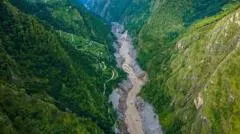
Nepal's devastating floods, which have killed more than 1,000 people, highlight a risk that extends beyond its borders into India, as the two countries share a vast and volatile network of Himalayan rivers. Experts say the link between flooding in Nepal and disaster in India is not straightforward, since it depends not only on rainfall in Nepal but also on conditions on the Indian side, including river levels, embankments, drainage and development.
Nepal has more than 6,000 rivers and streams, most flowing south into India and the Ganges, with the Kosi, Gandaki and Karnali among the major systems. Seven to nine major rivers cross into the Indian plains, with Bihar the worst affected state, as roughly three-quarters of north Bihar is officially flood-prone; eastern Uttar Pradesh is also significantly at risk but often overlooked, hydrologists say. Specialists describe flooding as a three-part chain: rainfall, often concentrated in the lower Siwaliks and Chure hills rather than the high Himalayas, determines the peak flow reaching the border, while conditions in India determine the severity of the resulting disaster, as illustrated by the catastrophic 2008 Kosi embankment failure.
In short
- Nepal's flood death toll has passed 1,000 people.
- Shared Himalayan rivers mean flood risk extends into India.
- Bihar and Uttar Pradesh are most exposed to transboundary flooding.
Steelman: both sides, in good faith
The strongest fair case each way — we don't pick a winner.
The case for
Nepal’s floods should concern India because rivers carrying heavy flows from Nepal cross into densely populated Indian plains, where Bihar and eastern Uttar Pradesh face substantial flood risk. Shared river systems mean upstream rainfall and downstream river levels, embankments, drainage and development interact, so cross-border monitoring and coordination could help limit harm.
The case against
Nepal’s floods do not by themselves show that India will face a comparable disaster: the effects depend on rainfall patterns and on conditions within India, including river levels, embankments, drainage and development. Treating the Nepal disaster as a direct forecast for India could obscure those local factors and the need to assess each river basin and flood season on its own terms.
Explained simply
Nepal lies high in the Himalayas, just north of India, and many rivers flow south from its hills and mountains into the Indian plains and the Ganges. The Kosi, Gandaki and Karnali are among the largest river systems shared by the two countries.
Heavy rain in Nepal can send more water downstream, but it does not by itself determine whether flooding becomes a disaster in India. River levels, embankments, drainage and development on the Indian side also affect the risk.
Bihar is especially exposed: about three-quarters of north Bihar is officially considered flood-prone. Eastern Uttar Pradesh is also at risk, and events such as the 2008 Kosi embankment failure show how damage to a river barrier can have serious consequences downstream.