Science news and discussion on TalkFuse.
Collapsed glacier likely caused devastating Nepal-Tibet floods, scientists say
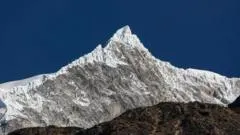
Scientists believe a glacier collapse near Nepal’s Langtang Lirung peak triggered the devastating flash floods on the Nepal-Tibet border, rather than an earthquake as initially reported. At least 469 people have died, and the event underscores growing concern that melting Himalayan ice and unstable mountain terrain are increasing the risk of catastrophic floods.
US Geological Survey data indicated that the collapse struck the valley with enough force to register as magnitude 5.2. ICIMOD said an ice-and-rock avalanche likely entered the Lende Khola river system, causing downstream water levels to rise by seven to nine metres in about 30 minutes and damaging monitoring stations. Experts say steep valleys may have intensified the flood, while tectonic uplift and climate-driven glacier melting may both have contributed to the unusually large collapse.
In short
- Glacier collapse likely caused Nepal-Tibet floods that killed at least 469 people.
- Water levels rose up to nine metres within 30 minutes.
- Scientists link the risk to unstable terrain and warming Himalayan glaciers.
Steelman: both sides, in good faith
The strongest fair case each way — we don't pick a winner.
The case for
The disaster supports the view that glacier retreat and destabilising mountain conditions are raising the risk of catastrophic floods, making stronger monitoring, early-warning systems and climate adaptation urgent. Scientists’ account of an ice-and-rock avalanche entering the river system offers a plausible explanation for the rapid rise in water levels and the scale of the damage.
The case against
The evidence does not establish that climate-driven melting caused this particular collapse: tectonic uplift, steep terrain and other local factors may also have contributed, and the event was initially attributed to an earthquake. A careful response should avoid treating one disaster as proof of a broad climate link before the causes are better understood, while still investigating the risks and improving preparedness.
Explained simply
The Himalayas contain glaciers, rivers and steep valleys that cross national borders, including between Nepal and Tibet. A glacier collapse can send ice and rock rushing downhill into a river, displacing water and causing a sudden flood far downstream.
Scientists study clues such as seismic readings, river levels and damage to monitoring equipment to work out what caused such events. The US Geological Survey records earthquakes and other ground movements, while ICIMOD studies mountain environments and risks across the Hindu Kush Himalaya region.
Glaciers are changing as the climate warms, and mountain slopes can also be affected by geological forces such as the slow movement of tectonic plates. Understanding how these factors interact matters for communities along mountain rivers, where early warning systems and reliable monitoring can help people prepare for floods.